"San Andreas Fault, aerial" - Vídeo de stock
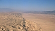
"Aerial photograph of the San Andreas Fault as it crosses the Carrizo Plain in California, USA. The San Andreas Fault extends almost the full length of California. It marks the boundary between the Pacific Plate to the west and the North American Plate to the east. These tectonic plates are moving past each other, making this a transform fault. The plates' movements cause stress that builds up until it is released by their sudden movement, which causes earthquakes. The desolate landscape consists of pressure ridges formed as a result of hundreds of fault movements. The Carrizo Plain is at right, the elevated Elkhorn Scarp at left."


COMPRAR UMA LICENÇA
Obtenha preços personalizados indicando-nos quando, onde e como pretende usar este ficheiro.
DETALHES
Crédito:
Creative nº:
618593235
Tipo de licença:
Rights-ready
Coleção:
Image Bank Film
Tamanho máx.:
1920 x 1080 px - 509 MB
Duração do clip:
00:00:10:00
Data do upload:
Inf. sobre autorização:
Não é necessária uma autorização
Masterizado para:
QuickTime 8-bit Photo-JPEG HD 1920x1080 25p
Categorias:
- San Andreas Fault,
- Sismo,
- Tectónico,
- Carrizo Plain,
- Deserto,
- Ninguém,
- Paisagem Árida,
- Califórnia,
- Divisa,
- Mudança,
- 10 Segundos ou Mais,
- Acidentes e Desastres,
- Ao Ar Livre,
- Caraterísticas do Território,
- Castanho,
- Céu,
- Dia,
- EUA,
- Estéril,
- Falha ativa,
- Filme - Imagem em Movimento,
- Formato de Alta Definição,
- Geografia Física,
- Geologia,
- Horizontal,
- Imagem a cores,
- Inclinação para baixo,
- Meio-ambiente,
- Natureza,
- Padrão Natural,
- Paisagem - Cena Não Urbana,
- Paisagem - Natureza,
- Plano Geral,
- Seco,
- Sismologia,
- Tempo real,
- Terra,
- Vista de Cima,